Reading a City Grid Without Following It Blindly
Reading a city grid helps you orient yourself, spot useful landmarks, and choose a route that makes sense on the ground—not just as a straight line.
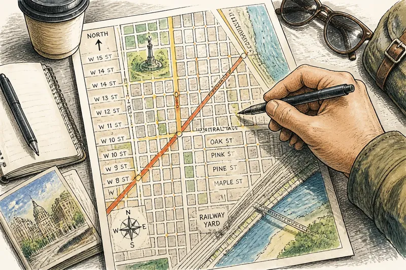
The common mistake in a city grid is assuming every straight line makes an easy walk. Reading a city grid can help you place yourself and your destination, but orderly blocks may hide a confusing street-name change, an angled intersection, or a boundary where the pattern shifts. Treat the grid as a clue to the city’s structure, not a promise that every corner behaves alike.
What can a city grid tell you?
A grid is a pattern of streets meeting at regular or nearly regular angles. It can give you a quick sense of direction: if a destination lies several blocks north and a few east, you can describe its general position before choosing turns. Numbered streets, sequential names, or a central avenue may make the pattern easier to recognize.
The pattern also helps you build a mental map. Notice which streets run parallel, where the numbers rise, and whether a major avenue divides one naming system from another. Those details can help you recover your bearings if you lose sight of a landmark.
But a block is not a dependable unit of effort or orientation. One may be short and busy; another may stretch past a blank wall or a rail yard. Think of the grid as a sheet of graph paper: it shows relationships, not what each square feels like to cross.
How do you read street names and directions?
Begin with the nearest intersection rather than trusting a street number in isolation. In some districts, numbering changes at a major avenue; elsewhere, neighboring areas use different naming conventions. A map’s compass and the cross-street name can confirm whether you are following the pattern you think you are.
Look for repeated clues. If avenue numbers rise as you move east and street numbers rise as you move north, those sequences form a simple local compass. Do not assume the rule continues across a river, civic center, or district boundary; check the labels again when the pattern changes.
Diagonal streets need a different reading. They can connect parts of a grid without following its north-south or east-west rhythm, and their intersections may create wedge-shaped blocks. Use them as orientation landmarks, but pay attention to how they meet the surrounding streets rather than forcing them into the grid’s logic.
How can you tell whether the grid has changed?
Look for a clear break in the pattern: streets that stop, shift direction, change names, or meet at unusual angles. A park, rail corridor, waterfront, campus, or large civic complex may interrupt the regular sequence. The map can still help you see how the neighborhoods relate, but the local street pattern may no longer offer a dependable shortcut to the next block.
Notice how major avenues, boulevards, and boundaries affect the layout. A broad avenue may mark a numbering reset; a diagonal may divide two sets of parallel streets. When the sequence changes, identify the nearest named intersection and orient yourself from that point instead of carrying the old rule forward.
Say you are on a numbered street and expect the next avenue to continue the sequence, but the map shows a diagonal avenue and a different street-name pattern beyond it. Treat the diagonal as a boundary, check the next labeled intersection, and use that name as your new reference. The result is a clearer sense of which side of the district you are in, even if the blocks no longer line up neatly.
What questions help you read an unfamiliar grid?
Why do numbered streets still feel confusing?
The numbering may change at a dividing avenue, or nearby districts may use separate systems. Check the nearest cross street and compass direction, then confirm the street label before assuming the sequence continues.
How should you interpret a diagonal avenue?
Use it as a landmark and note which streets it crosses. Its angle can interrupt the regular pattern, so orient yourself from a clearly labeled intersection on the side where you are standing.
What should you do when the pattern stops?
Pause at a safe place and identify the nearest named street or recognizable landmark. Rebuild your bearings from that reference rather than guessing which direction the old sequence would have taken you.
How can you remember your position without checking your phone constantly?
Keep two cues in mind: the street you are following and a nearby cross street or landmark. If those no longer match what you see, stop somewhere safe and check your location before continuing.
How do you turn a grid into a useful mental map?
Choose a few landmarks that describe the layout rather than memorizing every turn. A major avenue can mark the district’s edge, a diagonal street can signal a change in direction, and a distinctive square can anchor your sense of place. Note the names of intersections as well as their positions; names are easier to use when asking someone nearby to confirm where you are.
For a quick orientation check, write down or remember:
- Street sequence: If numbered streets rise in the direction you expect, use them as a local compass; if the sequence changes, reset your bearings at the next labeled intersection.
- District boundary: If a major avenue, river, or rail line divides the pattern, identify the crossing or boundary before assuming the same street logic continues beyond it.
- Diagonal streets: If a diagonal cuts across parallel blocks, use its name and intersections as landmarks; if its angle makes your direction unclear, orient yourself from a nearby named cross street.
- Distinctive landmark: If a square, station, or public building is easy to recognize, use it to check your position; if it is not visible, choose a street sign or another clear reference.
- Street-name change: If the same road gains a new name or the local numbering resets, treat that point as a new reference; if labels remain consistent, continue using the existing pattern.
- Block alignment: If streets remain parallel and intersections meet at familiar angles, use the grid to estimate direction; if the layout bends or fragments, rely on named streets and landmarks instead.
Reading a city grid well means knowing which clues still apply and which have stopped being useful. Keep the street names, boundaries, and landmarks in view, and you can rebuild your bearings when the pattern shifts—without expecting every neighborhood to fit the same tidy lines.
Before leaving a major intersection, glance at the street name you just crossed. That small reference can make the next turn easier to interpret and gives you a precise starting point if you need to ask someone for directions.